
Buy PDF guide

Buy PDF guide — 8.57 USD

PDF — 8.57 USD

SAXONY - Saxon Switzerland: Bastei rocks and hiking

SAXONY - Saxon Switzerland: Bastei rocks and hiking

Saxon Switzerland pairs dramatic sandstone cliffs with easy river villages and some of Germany’s most memorable trails. From the iconic Bastei rocks above the Elbe to the paths around Rathen, Bad Schandau, Königstein and Schmilka, it’s a compact escape made for hiking and big views.

🧭 DAY-BY-DAY ITINERARY

Ready-made country and city routes with daily plans, sights, transport and accommodation. Buy PDF guides for independent travel.

🧭 DAY-BY-DAY ITINERARY


Day 1 — Dresden → Bastei → Kurort Rathen

  • 🚆 Transfer: from Dresden, the most convenient way to reach the Saxon Switzerland region is by S-Bahn S1 toward Bad Schandau / Schöna. The ride to Kurort Rathen station usually takes about 35–45 minutes, followed by a short ferry crossing over the Elbe and the ascent to the Bastei viewpoints. If traveling via Bad Schandau, expect roughly 45–50 minutes from central Dresden to the region’s main hub.

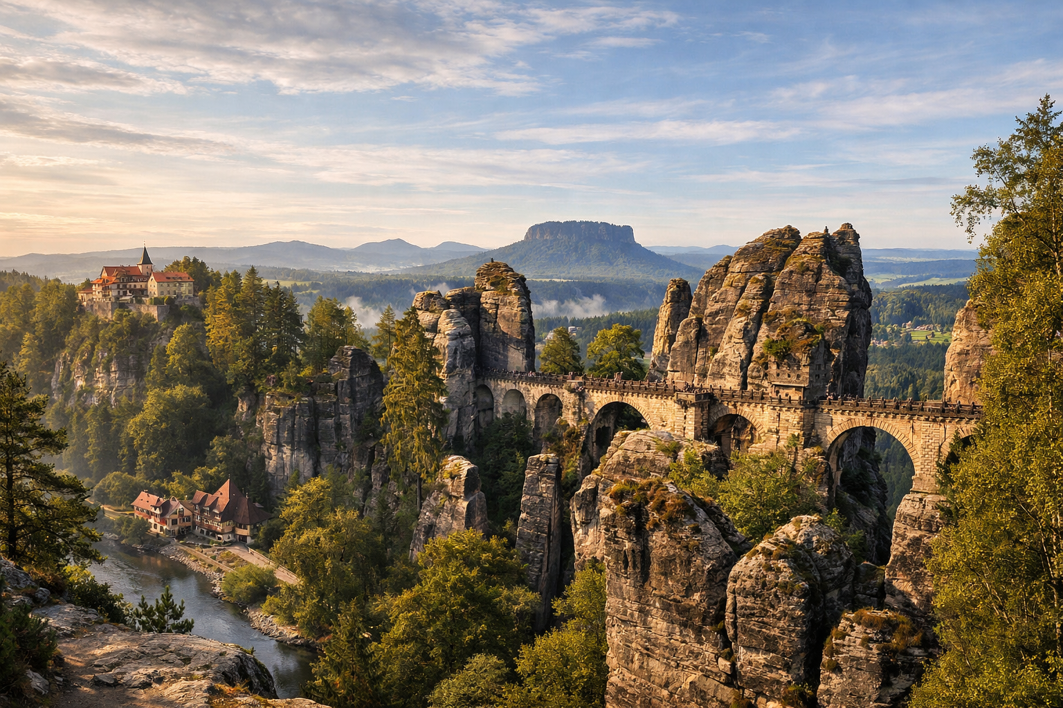
  • 🚶 Bastei is one of Germany’s most famous panoramas and, without exaggeration, a stone balcony above the Elbe that overwhelms you almost theatrically the first time. About 190 meters above the river, giant sandstone towers suddenly rise from the forest, split by gorges, bridges, and stairways. The most recognizable spot is Basteibrücke, the Bastei Bridge, stretched between the rocks as if the architecture here only carefully adapts itself to geology. From here you get that iconic view of the bend in the Elbe, the resort town of Rathen, wooded ridges, and an endless chain of gray-gold rock pinnacles that made Saxon Switzerland beloved by Romantics, painters, and photographers. It’s best not to rush: first walk the main terraces, then descend to the viewpoints, and then give yourself time just to stand in silence and catch the changing light, because that is exactly what turns Bastei from a beautiful stop on the route into a true emotional experience.

  • 🥾 After the main panoramas, it makes sense to dedicate the rest of the day to gentle hiking around Rathen. For the first day, it’s better to choose an easy rhythm: a walk along forest trails and viewpoints near Bastei, with breaks for photos and rest. For this kind of plan, 3–5 hours is a comfortable estimate, including the ascent, scenic stops, and a late lunch. If you arrive before noon, the day will feel full but not exhausting.

  • 🌄 In the evening, Rathen especially captures the essence of the region: the broad Elbe flows below, dark vertical sandstone walls rise above it, and the little villages along the riverbanks look as if they accidentally ended up among the scenery of an Alpine legend. This is the perfect evening not for racing between points, but for slowing down: a terrace, river air, and an early night before a proper hiking day.


Day 2 — Bad Schandau: NationalparkZentrum + Kirnitzschtal + hiking to rocky viewpoints

  • 🚆 Transfer: Rathen → Bad Schandau on the S1 line takes about 15–20 minutes. From the rail hub Bad Schandau Nationalparkbahnhof to the center, you often need to add a ferry or a short bus/walking connection, so it’s convenient to allow about 30–40 minutes door to door for the full transfer.

  • 🏛️ Start the day at NationalparkZentrum Sächsische Schweiz in Bad Schandau. This is not a formal visitor center visit just for the sake of it, but a very useful introduction where geology, landscape history, flora, fauna, and the logic of local trails come together into a clear picture. After visiting, the rocks stop feeling like merely beautiful shapes and begin to read as a vast sandstone world shaped by time, water, and erosion. This is also the right place to check trail conditions, seasonal restrictions, and choose a route based on how you feel and the weather.

  • 🚋 Next comes the famous Kirnitzschtalbahn, a historic tram line running from Kurpark Bad Schandau into the romantic Kirnitzsch Valley. It is one of the region’s most charming transport experiences: the carriage slowly disappears into a wooded gorge, and the ride itself already becomes part of the journey. The line is about 8 km long, and in season it is especially convenient as a gentle start to hiking without putting too much strain on your legs at the very beginning of the day.

  • 🥾 The main idea of the second day is not to chase maximum mileage, but to truly experience the landscape. From stops in the Kirnitzschtal, you can set out on routes to rock groups, forest trails, and panoramic platforms in the national park. For a 4-day tour, a moderate route of 4–6 hours with elevation gain, stairways, and necessary breaks for water and rest is ideal. Here Saxon Switzerland shows itself especially vividly: trails run between mossy boulders, roots, shady spruce sections, and sudden openings that reveal dramatic views of stone walls. This is not a “hike for sport,” but a genuinely cinematic passage through forest and rock.

  • 🌿 The evening is best left for Bad Schandau itself. The town is small, spa-like, and very convenient as a base: after trekking, it’s pleasant to walk along the Elbe, have a calm dinner, and do absolutely nothing else. In this region, rest after hiking is not lost time, but part of the right travel rhythm.

Day 3 — Königstein: Festung Königstein fortress + Elbe panoramas

  • 🚆 Transfer: Bad Schandau → Königstein on the S-Bahn S1 usually takes about 10 minutes, plus time for the ascent to the fortress. Including the approach, local bus, or taxi, it is reasonable to count on about 30–40 minutes for the whole transfer.

  • 🏰 Festung Königstein is not just a fortress, but an entire world on a stone plateau, one of the largest hilltop fortresses in Europe. It stands high above the Elbe Valley and looks like a separate state raised above the river. What matters here is not only the military history, but also the spatial sensation itself: once inside the walls, you find yourself on a huge rocky summit with streets, courtyards, casemates, bastions, exhibitions, and panoramas opening in every direction. This is not a fortress you “do in an hour”: it is better to allow at least 4 hours, or a full 5–6 if you enjoy museums and unhurried walks.

  • 🏛️ The exhibitions inside the fortress help you see this place not only as a beautiful shell, but as a real site of centuries-long life: defense, royal treasures, garrison life, engineering, warehouses, wells, cargo transport, and the everyday routines of people who lived on this isolated plateau. At the same time, even those who are usually indifferent to military-history museums tend to like Königstein because of its scale and views: the walls here do not feel oppressive, but instead open up space, and almost every exit to the edge becomes a viewpoint over the valley.

  • 🚶 After the fortress, you can leave time for a calmer rest of the day: a walk around the town of Königstein or a short scenic outing by the river. This is a good day for recovery after the full hiking day before: fewer stairways in the forest, more history, open platforms, and contemplation. In the evening, it’s convenient to return to Bad Schandau or stay closer to the park so you can begin the next day without any rush.

Day 4 — Schmilka: final hike and village by the national park

  • 🚆 Transfer: Bad Schandau → Schmilka-Hirschmühle on the S1 takes about 10–15 minutes, then a short walk or ferry crossing to the village itself may be needed depending on your chosen starting point. For the whole transfer, it’s best to allow about 25–35 minutes.

  • 🥾 Schmilka is the perfect finale to a Saxon Switzerland route. It is a small settlement right by the national park, where everything seems designed to combine an active day in the mountains with a very cozy end to the trip. Hiking feels different here than at Bastei: less of the immediate “first wow effect,” but more deep immersion in the forest, the river valley, and the atmosphere of a quiet borderland. From Schmilka, it’s easy to set out on trails of varying difficulty; for the last day, it’s best to choose a 3–5 hour route with elevation gain, stairways, and several viewpoints so you still have energy for the return trip.

  • 🌲 It is around Schmilka that the region’s contrast feels especially strong: below is an almost idyllic village on the banks of the Elbe, and after just a few dozen minutes of climbing, you are already surrounded by harsh rock walls, narrow passages, corridors of stone, and forest that sometimes closes off the horizon and then suddenly pulls back the curtain to reveal the broad valley. If the weather cooperates, the final panoramas become the climax of the whole trip: by this point your eye is already “tuned” to the relief of Saxon Switzerland, and the views read much more deeply than on the first day.

  • 🍃 After the hike, be sure to leave time for Schmilka itself. This place is known for its atmospheric “bio-refugium,” relaxed pace, good gastronomy, and the rare feeling that the journey ends beautifully rather than just technically. It’s pleasant to have a late lunch or coffee here, quietly catch your breath after the trail, and only then head back toward Dresden. Getting to Dresden from the region usually takes about 45–60 minutes by S-Bahn depending on your departure point.

Flight tickets

eSIM for travel

Buy PDF guide

Buy PDF guide — 8.57 USD

PDF — 8.57 USD